Updated 12.02.25
Monroe Mountain is one of the premier free flight launches in the US. Sitting nearly 6,000 feet above the valley floor, Monroe offers everything from a memorable sledder to epic cross country flights. With 2WD access, dramatic vistas in every direction, and a beautiful open launch….what more can one ask for?!
Monroe Peak is almost exclusively flown as a morning site by locals. Launch conditions are more often than not too strong to launch from Monroe in the evenings, so locals head to Cove, launching at a lower elevation. It is flown primarily June through November, and the road to launch is impassable much of the rest of the year due to snow drifts. Extreme caution should be taken during the peak heating months of June to August, as thermals can start by 10am and increase in strength rapidly. Experienced mountain pilots can confidently launch early and maintain while waiting for thermal strength to increase while newer pilots or those not accustomed to high altitude mountain flying can enjoy morning thermals before heading out to enjoy the 20 minute glide to the landing zone.
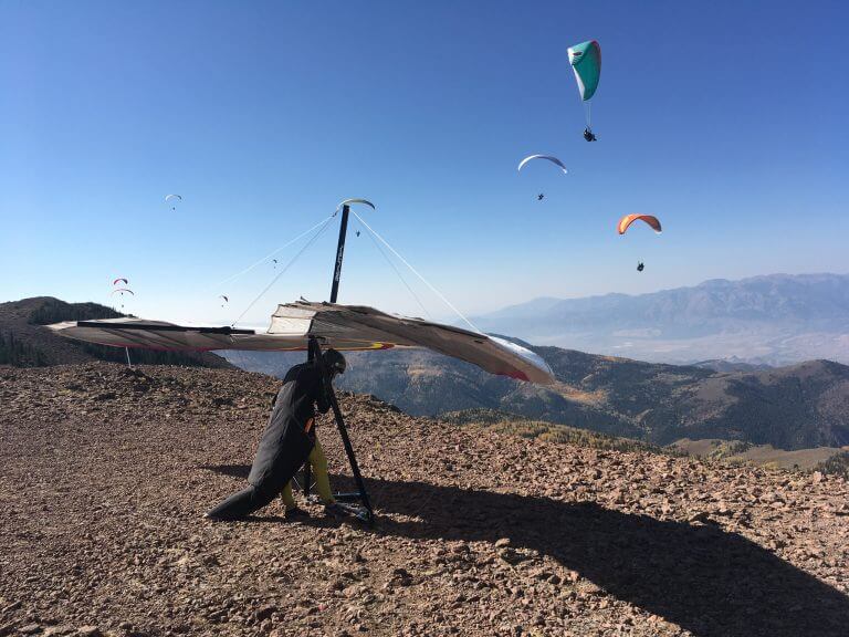
Monroe Peak is a high altitude launch requiring proficient forward launch skills and the ability to run through the entirety of a launch. An aggressive torpedo and fast, controlled take-off run is necessary due to the low air density.
Quick Info
- General Site Guidelines HERE
- High Altitude Launch (11,171 ft) means low air density and can require an aggressive, controlled torpedo. You must be able to run through the entirety of your launch.
- Supplemental oxygen recommended if pilot plans to fly above 12k ft. Pilots coming from sea level are recommended to use supplemental oxygen at all times. If you become short of breath, confused, or dizzy, IMMEDIATELY seek to safely descend and end your flight. If you are able, radio your position so other pilots can ensure you land safely.
- 6,000 feet vertical to LZ
- Primarily a morning site due to midday turbulence and wind speed that exceeds safe operating margins
- SW/W launch direction -Ideal 210-240, OK 200-280
- Recommended Wind: P3: Min 0, Ideal 8, Max 12, gusts to 5
- H3: Min 8, Ideal 12, Max 20, gusts to 5
- P3/H3 or supervision required
- Skills needed but not limited to high wind launching, high wind kiting, no wind launching, active piloting in turbulence, high altitude launching, high altitude landing, descent techniques, thermalling, and ridge soaring
- Miniwings not recommended
- 5.4 Min. Glide Ratio to LZ
- Membership in USHPA and CUASA. CUASA membership form HERE
- Real-time Weather Station HERE
Launch
Coordinates:
38 32’29”N 112 04’24”W
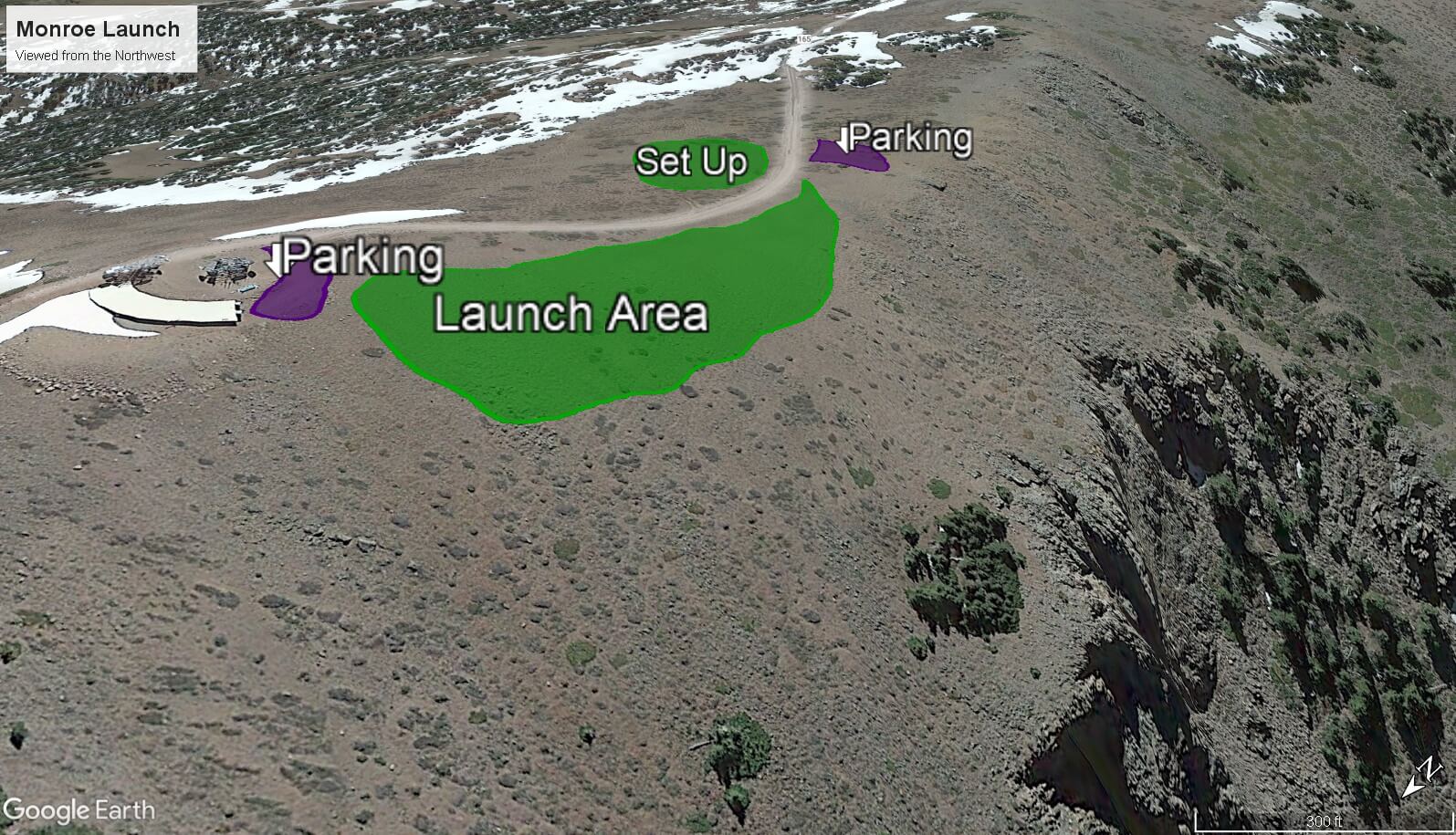
Located 7 miles South East of Monroe Utah at the top of the Monroe Mountain Rd. 2wd accessible in dry conditions. Typically snowed in November-June.
Monroe peak is a high-altitude mountain launch sitting at 11,171 ft asl. At such altitudes, a strong torpedo launch is required due to the thinner air. An aggressive torpedo and fast take-off run is a must. High altitude general flying information can be found HERE.
The launch is a SW facing wide gravel area that can accommodate multiple gliders at once. However, please keep launch clear and set-up gear in another area if other pilots are present. With multiple pilots on launch, please say “launching” loudly before inflating.
Cross winds from the North and South should be avoided. Be aware of many small rocks and snags on launch. Clear all lines before inflating. Larger rocks near the launch zone should be noted before take-off and avoided. A Few trees are in the line of flight if one has a delayed take -off. These trees are easy to avoid by making a shallow turn away to the north or south or by aborting launch and trying again. Beyond the trees and below launch is a steep rocky cliff. There is a long runway before one comes close to the edge, but make sure to abort launch if you are not in the air near the edge.
Please note the location of the tower located to the North and south of launch. Avoid flying close to these.
Flying
There is a 5.8 mile glide to the LZ, so it is recommended to head out towards the valley if you are 100 ft below launch. Excellent thermal triggers exist along the ridges that lead to the valley, so there is no need to “scratch” close to or below launch.
Ridge soaring and thermal flying opportunities are possible from Monroe peak depending on conditions. Being such a high mountain site, thermal activity can begin early in the morning. In general, thermals begin light and get stronger as the day progresses. Be aware that thermal activity can become very strong quickly. Stay within your operating abilities.
A flight path that keeps clearance above or allows a route around the Blue Fin Ridge is paramount. Blue Fin Ridge can create a barrier between pilots and the LZ as it sits in the direct flight path. When in doubt, fly straight to the West towards the valley and fly around it, or land in one of the abundant fields.
Pharoah’s Tomb, highlighted in the map at the bottom of this page, is an area of shallow angled terrain that should not be flown directly over without sufficient altitude. How much altitude needed is based on many environmental factors, including wind direction, but higher is always better! Conservatively, 12k is a minimum altitude before attempting the crossing. 14k or higher is better for a safe crossing and optimal positioning above Cove for the next thermal. This area is known to have abundant sink without many safe landing opportunities if one finds themselves low in the Tomb. Long hikes await those who land out. To mitigate landing in the Tomb, the suggested flight path is to fly out toward the main valley in an arc toward Cove Launch. This should allow pilots the option of always gliding out toward the valley and safe landing options in case too much sink is encountered.
There are high-tension power lines that run N-S along the base and foothills of the mountain. If you have any doubts about clearing these, land before them.
There is a local airport located in Richfield. Pilots should give the runway a wide berth if flying in that direction and make sure to not land on the runway. We experience general aviation traffic from time to time near the mountains. Pilots should keep aware of other air traffic and practice see and avoid at all times.
Landing Zone
Coordinates:
38.618956, -112.115687
The landing zone has been graciously offered to free flight pilots form the city of Monroe. Through cooperation between the city and CUASA, a strip of grass running N-S, a grassy packing area to the East of the landing area, and a public restroom has been erected.
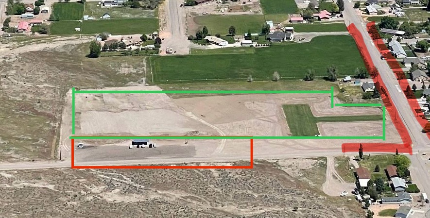
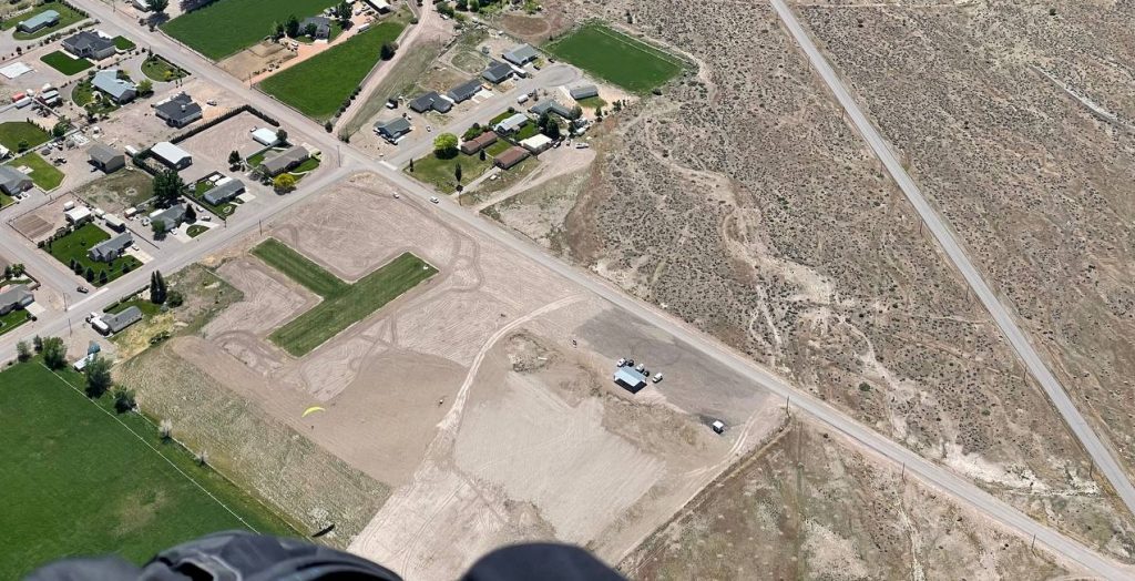
The Monroe Landing Zone is a wide-open, ideal landing area. However, some precautions should be taken.
Wind direction upon landing can vary, so the several wind indicators placed around the LZ should be checked on approach. Even though the N-S running “strip” is often used for landing, it is not necessary. The landing zone is a very large field that allows for any approach direction. Be aware that the farther West one lands in the landing zone field, the more undulating and rocky it becomes.
The field is located on the South end of Monroe and has a few municipal hazards that should be noted.
- Houses, powerlines, and trees can be found on the SE, E, and NE corners of the LZ. Please take caution to keep plenty of clearance above these areas.
- A public road runs along the South border
- A horse corral is located to the West. We have been asked not to fly “low” directly over this corral. It tends to spook horses.
Bail out landing options are possible to use if you are not going to make the Landing Zone. The most popular area is the Training Hill LZ. It’s not a bad idea to see it for oneself before flying.
A final note on the LZ. In the past, camping was welcome near the LZ but has since been forbidden. Plenty of BLM land and other camping options are available in the area. Please use those instead
