Updated 12.02.2025
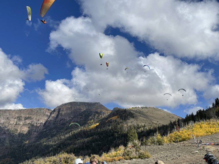
Located 12 miles Southeast of Richfield, Utah, Cove offers a spectacular flying arena. Sitting 3000′ above the Sevier Valley floor, pilots can enjoy extended sledder flights, soar along the dramatic cliff faces, and even get boosted to 17,999′ regularly.
Cove is a high-desert mountain launch and requires the associated respect and caution needed to fly in such an environment. High altitude general flying information can be found HERE. Strong thermal activity can begin early in the morning and last late into the evening. As a West facing mountain, strong thermals often last into the evening hours but typically mellow with the waning sun. As a general rule, thermals tend to mellow starting 2 hours before sunset, but not guaranteed. Lift may last beyond dusk so it is imperative to have proper descent techniques in one’s arsenal of skills.
Launch
Launch, at 8700 feet, is located 6 miles up Thompson Basin Road which requires a high-clearance vehicle. It is typically snowed in from November-May.
Vehicles should park on the East side of the road for West and North launches and park to North of road for south launch. Spectators should give pilots at least 50 feet of clearance, this is easy to do if staying within the parking area.
Launches can be found on the North, South and West faces, allowing for flights in all wind directions except those with an East component. Use caution when choosing a launch as the wind can often “wrap” around and pose a false sense of wind direction. Double check all wind indicators are facing the same direction.
Take note of the large towers present on launch. Pilots should avoid flying close to these.
Quick Info:
- General Site Guidelines HERE
- High-altitude launch at 8,700 ft means low air density and can require an aggressive, controlled torpedo. You must be able to run through the entirety of your launch.
- Supplemental oxygen recommended if pilot plans to fly above 12k ft. Pilots coming from sea level are recommended to use supplemental oxygen at all times. If you become short of breath, confused, or dizzy, IMMEDIATELY seek to safely descend and end your flight. If you are able, radio your position so other pilots can ensure you land safely.
- N/W/S launches possible
- Ratings: See Individual Launches Below
- Min. Glide Ratio: 5.0
- Recommended Wind: See Individual Launches Below
- Skills needed but not limited to high wind launching, high wind kiting, no wind launching, active piloting in turbulence, high altitude launching, high altitude landing, descent techniques, thermalling, and ridge soaring
- Membership in USHPA and CUASA. CUASA membership form HERE
- Real-time Weather Station HERE
North Launch:
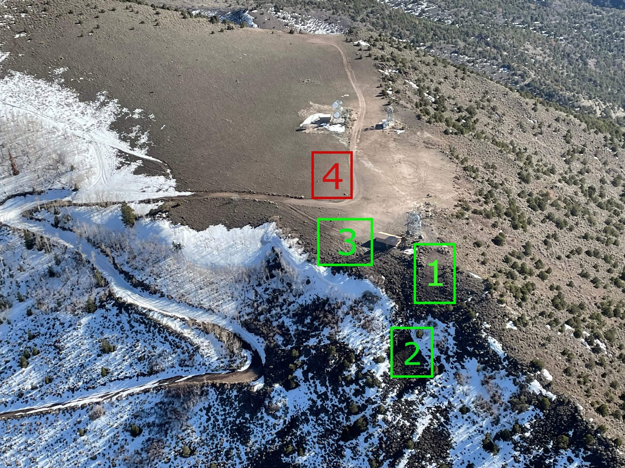
2. Lower Launch (High Winds)
3. Ankle Breaker Launch (Must have kiteable wind) 4. Parking Area
Often used, as North is the predominant valley flow. Multiple launch areas available.
In light winds (<7mph,) the North “Point” (#1) is ideal with enough room for a single glider at a time. This launch can become dangerous in higher winds as it is bordered by a sharp drop-off to the West. Rocks, snags, and bushes surround the takeoff. Beware of the towers and building in proximity to this launch. As with all of our launches, strong kiting skills may be necessary.
Use Parameters
- H3, Min 8, Ideal 12, Max 20, gusts to 5
- P3, Min 0, Ideal 5, Max 10, gusts to 5
- M2, Min 5, Ideal 10, Max 15, gusts to 3
- Wind Direction: Ideal 1-25, OK 355- 40
- Glide Ratio: 5.0
For higher wind launching, the North Lower launch (#2) is ideal. Tarps are laid out with enough room for two gliders at a time. This is a “side hill” launch, so make sure you have very good kiting skills! Often, one is in the air quickly after inflating.
Wind Speeds and Ratings
- P3, Min 3, Ideal 7, Max 14, gusts to 5
- Direction: 1-15, OK 340-35
- Glide Ratio 5.0
Once dubbed “Ankle Breaker” because of the need to inflate the wing and then kite through a slew of boulders before being lifted off, the launch to the East of the towers (#3) has seen a lot of improvement over the years. That said, this is an advanced launch that requires excellent kiting skills and a base wind speed >7mph. One needs to inflate their wing in the obvious clear zone to the East of the building, carefully kite to the edge and use dynamic lift to take off. If the wing is not pressurized and tugging you up and off near the edge, DO NOT LAUNCH. There is a very real danger of not having sufficient lift and flying directly into the trees below.
Use Parameters
- P3, Min 5, Ideal 8, Max 14, gusts to 5
- Direction: Ideal 1-15, OK 340-40
- Glide Ratio 5.0
West Launch:
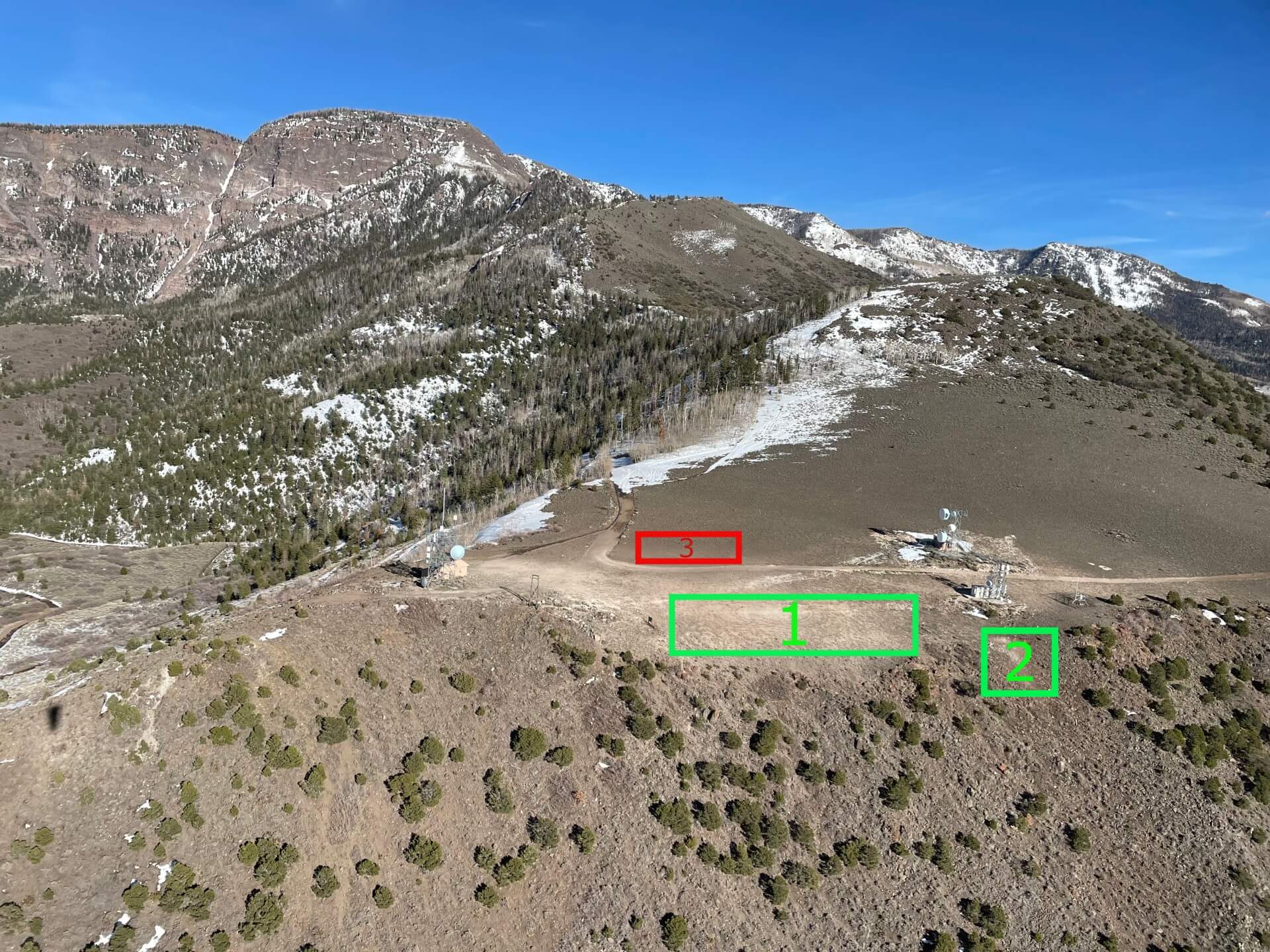
2.Hang Glider Launch
3. Parking Area
Large enough for multiple gliders to lay out at a time. Take care to clear lines from any snags before inflation. The take off area is gravel, but many small snags exists. The west launch is a low-angle ramp to sharp drop-off, make sure the wing is overhead before committing to launch. Often, a wind shadow is created near the edge of the take off making inflation difficult, so it is best to set up farther back towards the road and kite the wing toward the edge. In light winds, a very strong, committed forward torpedo is required!
Take a moment before setting up to note the small powerline running up the west face of Cove. It extends about 15 feet above ground level. Give yourself enough clearance above the ground if soaring the west face to avoid this obstacle.
With multiple pilots on launch, please say “launching” loudly before inflating.
Often, a NW wind presents itself on launch and can make it tricky to pick between W and N launches. Observation and patience is neccessary. Pay extra attention to the wind indicator to the East of the road, as it is generally the truest indicator of wind direction. West cycles can often overpower a light NW wind and make the West launch ideal, but good judgement is required since one could be launching into rotor from the North ridge.
Use Parameters
- H3, Min 5, Ideal 8, Max 20, gusts to 5
- P3, Min 0, Ideal 6, Max 12, gusts to 3
- M2, Min 2, Ideal 8, Max 15, gusts to 3
- Direction, Ideal 260-280, OK 225-315
- Glide Ratio 5.0
South Launch:
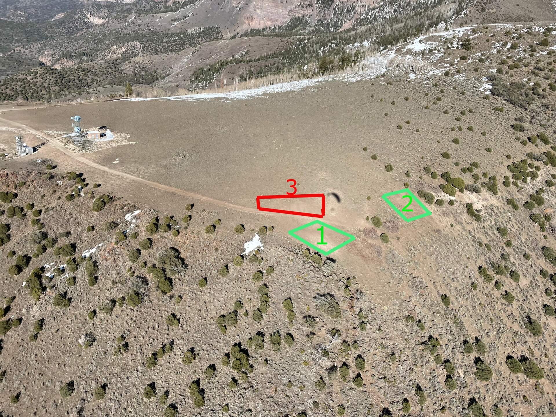
2. New launch, use in a SSW wind
3. Parking Area
Two possible launches to the South; with the area to the East being better when there is a SW component. Room for one to two gliders at a time. Many snags exists, so double check lines before inflating. Beware of rotor produced by the South ridge if the wind comes from the West.
Use Parameters
- H2, Min 5, Ideal 10, Max 20, gusts to 5
- P2, Min 0, Ideal 6, Max 12, gusts to 3
- M2, Min 2, Ideal 8, Max 15, gusts to 3
- Direction: Ideal 170-195, OK 160-210
- Glide Ratio 5.0
Flying
It is recommended that you head for the LZ if you are 300 feet below launch. A 2.5 mile glide out to the landing zone over mountains valleys and unfriendly landing conditions is required from launch, so head out to the LZ while you are still high enough to make it. Being aware of wind direction and staying alert to changes (as it often changes with altitude) is very important to protecting yourself from lee side turbulence and rotor. Remember, when in doubt, head out!
Choose your flying windows appropriate to your skills. The air in Central Utah can become extremely turbulent and active piloting skills as well as proper descent techniques may be required to fly and land safely.
There are high-tension power lines that run N-S along the base and foothills of the mountain. If you have any doubts about clearing these, land before them.
It is possible to soar from every face depending on wind direction to the top of Signal Peak (11, 100 ft.) Have plenty of clearance above each ridge before pushing back to the next higher ridge as you work your way up making sure you are able to glide out to the valley in case sink is encountered.
Cove is an excellent cross country venue offering flights from 5 kms to 200+ kms. Flights in all directions are possible, but be prepared before taking off into the unknown. As a high desert arena, extreme turbulence, rapid overdevelopment, and other hazards may be encountered. Walk-outs after landing can be long and arduous, often without cell service. Satellite tracking devices are encouraged.
Mini wings should be extra cautious of the glide to the LZ, as a minimum glide ratio of 5.2 is required to make it.
There is a local airport located in Richfield. Pilots should give the runway a wide berth if flying in that direction and make sure to not land on the runway. We experience general aviation traffic from time to time near the mountains. Pilots should keep aware of other air traffic and practice see and avoid at all times.
Landing Zone
Coordinates:
38.618956, -112.115687
The landing zone has been graciously offered to free flight pilots form the city of Monroe. Through cooperation between the city and CUASA, a strip of grass running N-S, a grassy packing area to the East of the landing area, and a public restroom has been erected.
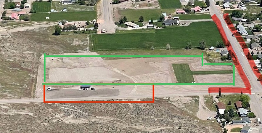
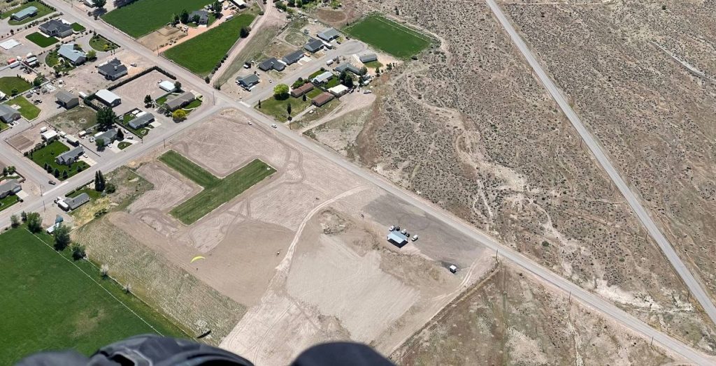
The Monroe Landing Zone is a wide-open, ideal landing area. However, some precautions should be taken.
Wind direction upon landing can vary, so the several wind indicators placed around the LZ should be checked on approach. Even though the N-S running “strip” is often used for landing, it is not necessary. The landing zone is a very large field that allows for any approach direction. Be aware that the farther West one lands in the landing zone field, the more undulating and rocky it becomes.
The field is located on the South end of Monroe and has a few municipal hazards that should be noted.
- Houses, powerlines, and trees can be found on the SE, E, and NE corners of the LZ. Please take caution to keep plenty of clearance above these areas.
- A public road runs along the South border
- A horse corral is located to the West. We have been asked not to fly “low” directly over this corral. It tends to spook horses.
Bail out landing options are possible to use if you are not going to make the Landing Zone. The most popular area is the open BLM land near Red Hill Hot Springs. It’s not a bad idea to see it for oneself before flying since sage brush and rocks litter the area and it is down-sloping to the West.
A final note on the LZ. In the past, camping was welcome near the LZ but has since been forbidden. Plenty of BLM land and other camping options are available in the area. Please use those instead.
